
7 top excursion and hiking destinations in and around Salzburg
An ever-increasing number of people who live in Salzburg spend their summer, and usually their holidays as well, in Salzburg. And this is not necessarily due to overcrowded beaches, expensive hotel accommodation or the increasing flight chaos. Salzburg has a lot to offer: deep green forests, turquoise lakes and breath-taking valley and mountain trails. You can also get to most of them with public transport or by bike. This post will show you some of the excursion and hiking destinations that have something to offer for all.
There is a lot to discover in Salzburg. To narrow it down a bit, we’ve compiled a list of selected excursion and hiking destinations in Salzburg that are easily to get to by bike or public transport. You can of course also drive, but for the sake of the environment we’d rather leave it parked at home. Our tips are not ranked or graded and are based more on personal experience. Enjoy!
#1 Bluntautal
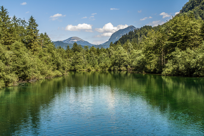
Recharge your batteries with a leisurely walk to the emerald green lakes (see cover picture) of the Bluntau Valley. Food for the soul!

Once you have arrived at the entrance to the valley, you can start your circular hike either to the left or to the right. If you hike around the lakes along the Torrener stream and back to the Bärenhütte, the whole hike takes about 2.5 hours – not including photo stops or lunch breaks (e.g. at the Bärenhütte or directly at the lakes). From the Bärenhütte, it takes another 30 minutes to reach a small waterfall.
If you take a seat on one of the numerous wooden benches around the lakes or directly on the Ache, you can let your eyes wander up the rocky faces of the Berchtesgaden Alps. They are connected to the Göll Massif by the Hagen Mountains. If your stomach is rumbling after having left the valley, you can also stop at Gasthof Göllhof, a traditional Austrian restaurant, for a bite to eat.
How to get there:
If you’re the sporty type, there’s nothing to stop you from taking a bike tour to the Bluntau lakes. The ride along the Salzach takes less than 2.5 hours.
The journey from Salzburg main or south station with the S-Bahn or regional express is much faster and less strenuous, that’s for sure. You will reach Golling-Abtenau in just under 40 minutes. Trains leave every 15 minutes. Once there, follow Bahnhofsstraße (on the right) until you reach Wasserfallstraße. Turn right there and cross the bridge. Then turn left and walk back along Bluntaustraße to the valley entrance. The walk shouldn’t take longer than 30 minutes.
#2 Golling Falls
You’d like something a little “cooler”? No problem. We’re now off to the Golling waterfall (Gollinger Wasserfall), which is found in Torren (Romanesque for “roaring torrent”). The water plunges over two falls down a total of 75 metres.

You can watch the spectacle daily from 09:00-18:00. The entrance fee (€3 for adults the last time we checked) can be paid at a small wooden hut, which stands in front of the path leading to the waterfall. It only takes a few minutes to get there from the entrance. You can also see the whole thing from above. It takes about half an hour to climb up to the top via the steps. The natural water rushing down the rocks creates an excellent air quality, by the way. Take a deep breath!
If you would like more information (e.g. on the current entrance fees), you can find it on the tourism page of Golling. You can also combine a visit to the waterfall with a hike to the Bluntau lakes. To do this, follow the path through a field and forest path near the Torrenerhof farm, where you will find a Bachtei chapel. Then keep to the left and you will eventually reach the Bluntau valley. Gasthof Abfalter or Landgasthof Torrenerhof are ideal for fuelling up on food and drinks before or after your excursion.
How to get there:
You can reach Golling Falls by bike in 1.5 to 2 hours. Too long? You can of course take the S-Bahn to Golling instead. From the station, you just have to follow the signs towards Bluntautal. The walk from the town centre takes about 45 minutes.
#3 Gaisberg
It’s a 592-metre climb if you want to experience one of the most beautiful vantage points in Salzburg. The city’s local mountain is not far from the city centre: the Gaisberg. But what can you find there? Road and mountain bike routes, beautiful hiking trails and lots of paragliders. Depending on the route you choose, you’ll need between 2 and 3 hours for the hike up there. The walk requires some fitness, good footwear and enough refreshments to keep you going.

The Gaisberg is not one of THE hiking destinations near the city for nothing – it offers variety. Where you start your hike depends on how challenging you want the route to be. A very beautiful and therefore popular route is the one that takes you from Parsch to the mountain in about 3 hours. Starting at the O-Bus stop Ludwig-Schmederer-Platz, you’ll walk along Judenbergweg and follow the route of the former cogwheel railway, which transported countless visitors up the mountain in 1887 (more information here in German). On your way you will pass the Zistelalm and reach the summit cross after another 4 kilometres. You can find an overview of the routes and their level of difficulty here.
The Gaisberg is not stingy with culinary offerings either. You have the choice between Kasnocknwirt, Rauchenbühelhütte, Goasn Wirtshaus, Goasn Alm, Zistelalm and Gersbergalm (most pages are in German). The latter two establishments also offer overnight stays, by the way.
You can also decide whether you want to climb the mountain yourself or just be driven comfortably up to the Zistelalm (see directions below) to do the Zistelrunde (duration approx. 1 hour) or the Gaisberg-Rundwanderweg (duration approx. 1.5-2 hours). The most beautiful sunset, however, can only be seen at the top.
The Gaisberg is also impressive in autumn, when you can see the colourful gradients of the forests from above – find some more impressions and information here (post in German).
How to get there:
If you are looking for a more leisurely excursion, you can take the number 151 bus from Mirabellplatz (next to the Mozarteum University), which will take you up the mountain. From the Zistelalm bus stop at the top, you will find signposts for various hiking trails.
But if you are tempted by a small, manageable but challenging mountain hike, all you have to do is find a starting point. There are a few points to choose from. You can reach them easily by bike or by taking the bus. Starting point 1: Lines 2, 23 and 151 will take you to Obergnigl or to the Gnigl primary schools. Starting point 2: Take line 6 (stops at Ludwig-Schmederer-Platz) or 7 (bus stop Aigen S-Bahn or Josef-Kaut-Straße). Find out which routes to follow from these starting points in the information leaflet linked above.
If you like a challenge, you can of course give cycling up the mountain a try. The best place to start is in Aigen at the St. Virgil cultural centre (Kulturzentrum St. Virgil). After some partly wooded and rougher terrain, you’ll reach an 800m long stretch of road, the Gaisbergstraße. The 15% incline is only suited to someone who is very athletic. Beware of traffic on the ascent and descent!
#4 Untersberg & Wolfschwangalm Nature Park
Now we’re off to the Untersberg – but not up it in this case. At the foot of the imposing Salzburg mountain is the Untersberg Nature Park.

The trail starts in the Latschenwirt restaurant car park. From there, you can either take the left, more leisurely path or turn right, where you will cross a small bridge and then hike gradually uphill until you reach the Wolfschwangalm. The left path leads you on a trail past a forest hermitage and a beautiful Kneipp facility to the Wolfschwangalm. Once there, you can enjoy the view of the Berchtesgaden mountain landscape and fortify yourself with a hearty meal or homemade baked goods.
On either route, it usually doesn’t take much longer than 30 minutes to reach the Alm. If you want to stop at the individual stations of the forest quiz or take a dip halfway through, it will of course take a little longer. Before you reach the car park of the Wolfschwangalm, you can make a detour to the Plainburg ruins. The walk will take 10 to 15 minutes, with a great view to greet you at the end.
How to get there:
If you’re feeling up for it, you can cycle your way to the Latschenwirt. The fastest route is via the Großgmainer Landstraße and takes just over 1 hour if you start from the city centre. Be aware that there are also some closed or private stretches of road along the way. After the open-air museum a little further on, you will be able to see signposts leading to Buchhöhstraße on the left (uphill stretch) and back to the Latschenwirt.
If you want to take it a little easier, just take the number 180 Postbus instead. From the stop Abzw. Latschenwirt, you can take a leisurely walk back to the inn, where the trail begins.
#5 Glasenbach Gorge
Hiking on a hot summer day? “Not your thing”, you say? Not so fast. Some paths lead you to cool lakes or through a shady gorge, just like this one. Introducing the Glasenbach Gorge.

Here you can hike alongside towering rock formations and along the Klausenbach stream. At spots where there is not too much water flowing through the gorge, you will find beautiful natural pools. Just find a suitable spot, lay out your towel and enjoy the refreshing air
There are several information boards along the 3 km long gravel path leading through the gorge. You can read interesting information about the geology of the gorge, plant occurrences and fossil finds. It hasn’t just appeared out of nowhere. After all, a fish dinosaur (Ichthyosaurus) that lived 200 million years ago was found in the Glasenbach gorge. Some parts of the skeleton are on show in Haus der Natur (the city’s natural history museum) in the city centre.
Good footwear, alpine huts and the Dry Gorges
Sturdy shoes are advisable even on hot summer days and on this ‘easier’ route, as it can be slippery in places. You should also bear this in mind if, for example, you continue walking on to the Fageralm and/or Erentrudisalm when you come out the other side of the gorge. This wil add another 1.5 hours on to your walk and is for reasonably experienced hikers. Coming from the south (Elsbethen-Zieglau), you can also hike to the alpine fields. On this trail you can explore the Dry Gorges, which were formed by the melting of the Salzach glacier.
How to get there:
As in many other cases, the best option for this excursion is to get on your bike. You can’t go wrong here, because the cycle path runs almost exclusively along the Salzach – just choose a side! For some orientation:
- Ride along the right bank of the Salzach: to Hellbrunn Bridge and on to Glasenbach
- Cycle along the left bank of the Salzach: from Überfuhrsteg, Wilhelm-Kaufmann-Steg or Hellbrunn Bridge you can cross over to the other side. Turn right at the roundabout in Glasenbach. The journey will take around 20 minutes. If you add another 3 kilometres, you will be in Elsbethen-Zieglau and can enter the Dry Gorges.
If you prefer to travel by bus, take the O-Bus 7 or No. 160 to Glasenbach (to Elsbethen-Zieglau to reach the Trockene Klamm). You can also take the S-Bahn or O-Bus 3 and 8 to Salzburg Süd train station (from the exit in the direction of Elsbethen it takes about 10 minutes). Walk on pass the Nautilus pharmacy, cross the bridge and continue along a forest path to get to the Glasenbach Gorge.
#6 Eibensee
Fuschl am See is well-known, popular destination for excursions. The surroundings offer dozens of opportunities for sports activities or simply to relax and unwind. Our recommendation: Eibensee – a beautiful, small mountain lake between Fuschl am See and St. Gilgen.

Start your hike at the Voderwald farm (located on the Wolfgangseebundesstraße) and follow the Eibensee stream on the forest road until you reach a fork in the road after about 30 minutes. On the left is the Drachenwand, on the right you will reach an extensive moorland called Wildmoos. This is a nature reserve (1,000 metres above sea level), the end of which has a last uphill stretch leading to Eibensee. A densely wooded path will eventually lead you out to the lake, which boasts an impressive view. There are many places along the shore where you can stop and put up your feet.
Those looking for a little more can take the path up to the Marienköpfl. The lookout point with its summit cross is only about 15 minutes away from the turnoff down to the lake and offers an impressive view of the neighbouring mountains, such as the Schober and the Schafberg.
How to get there:
Of course, you can also cycle to the starting point here. However, as this takes a little time, we advise you to take the number 150 bus. This leaves from the main station and will take you past Fuschl am See to the Abzw. Eibensee bus stop.
#7 The Großer and Kleiner Barmstein
Are the mountains calling you? Well, get on up there! To be more specific: we’re going up the Barmsteine or “Barmstoa“. The route starts in Hallein, from where you can climb up the two rocky outcrops (Kleiner Barmstein: 841 metres, Großer Barmstein: 851 metres) on the north-eastern edge of the Berchtesgaden Alps. In many places you will find steps cut into the rock with railings or even wire ropes. As you can see here, it is not the usual walk. Sturdy footwear is a must.

The Kleine Barmstein
The approach to the Kleiner Barmstein is on the southern side. To get up there, follow the Domenigweg (shortly after the Kleinkirchentalweg fork) up to the Alois Oedl Steig. This route will also lead you to the Thürndl ruins, built in the second half of the 13th century. After a short break, head back towards the forest area. When you reach a staircase, you might have to clench your teeth again before you reach the summit of the Kleiner Barmstein. You will now have a view of the Osterhorngruppe, both the Tennen and Hagen mountain ranges and the Watzmann. You will also be able to see the Göll, the Hochkalter, the Untersberg and of course the Großer Barmstein.
The Große Barmstein
Walking back, you will soon see the signposts for the Großer Barmstein. At the beginning of your ascent, you can secure yourself with ropes attached to the rock face, before continuing on a well-trodden path to the summit. This path is mostly root-covered, stony and not for people with a fear of heights. You need to be more experienced if you want to work your way up to the Großer Barmstein. Once you have made it up there, a breathtaking view of Hallein awaits you.
We have to admit the hike to the Großer Barmstein is admittedly steeper than other hiking trails mentioned here, at least right up to the sign “Großer Barmstein – 30 min”. Still, the route is not impossible. The terrain from this point onwards, however, is very exposed and caution should be taken. Again, experience is required.
How to get there:
To save energy, we recommend taking the S-Bahn to Hallein. Take the number 41 bus towards Bad Dürrnberg (bus stop Hallein Fuchsturm). Then follow the directions.
Well? Were you taking notes? Well, if not, it doesn’t matter. You can always come back to find all the information you need about excursions and hiking destinations in Salzburg in this post. All you have to do is get started. If you’re short for time or simply don’t want to cover the distance described here, you can of course just walk a few steps up to the Kapuzinerberg (blog post in German), fuelled by a coffee in the city centre, of course.
Your commUNIty team
Photo credit (Barmstein photos): Dominik Hutter-Marrollo
Other photos: commUNIty team

