
Geologie Laufende Projekte
-
AlpLakeChange
Biodiversity and Climate Change – A Transdisciplinary Approach
Projektleitung: Stephen Wickham
Partner Investigators: Ulrike Berninger, Sylke Hilberg, Jan-Christoph Otto, Jana Petermann. Kyoko Shinozaki
Dissertant: Florian Hohenberger
The transdisciplinary project “AlpLakeChange”, funded by the Austrian Academy of Sciences (ÖAW), focuses on biodiversity change in alpine waters in the Hohe Tauern National Park. Mehr -
CANVAS
Craquelure Analysis via Neural Vision and Surface-Scanning wird finanziert durch „KI-Forschung Salzburg 2025“ (Wissenschafts- und Innovationsstrategie (WISS) 2030, Land Salzburg)
Projektleitung: Christoph v on Hagke
Projektpartner: Andreas Uhl
Das Projekt untersucht feine Rissmuster in alten Gemälden dreidimensional und hochauflösend. Ziel ist es, Originale sicherer von Fälschungen zu unterscheiden, das Alter von Kunstwerken präziser zu bestimmen und Museen sowie Kunstexperten bei der Bewahrung des kulturellen Erbes zu unterstützen. -
COOL
Projektleitung: Bernhard Salcher
Local Pleistocene mountain glaciers in the Alpine-Carpathian belt and their paleoclimatic significance. Funding: ÖAD. In cooperation with AGH and Jagiellonian University, Krakow. -
Effects of rapid climate and land-use change on species diversity across a mountain front
Supervisor team: Bernhard Salcher, Jan Habel, Andreas Tribsch, Anja Hörger, Jonas Eberle, Jörg Robl, Beate A. Apfelbeck, Mathias Hopfinger
PhD Student: Marianna Mattrazzi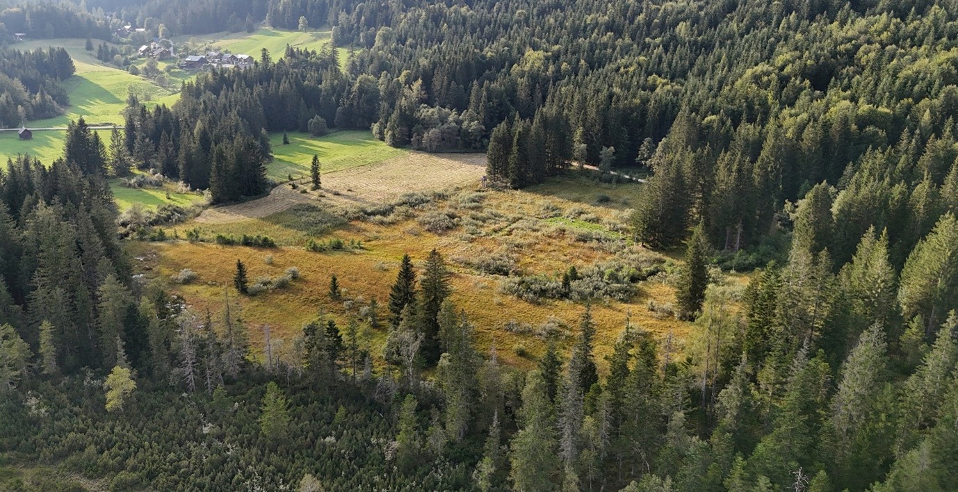
Alpine habitats react very differently to climatic change and human induced modifications of the landscape. This project focuses on Alpine peatlands to analyse effects of rapid climate change and anthropogenically induced impacts of land-use on species diversity and species community composition. Peatlands are particularly sensitive to record these effects and are important archives to determine climate and environmental change over time periods often exceeding 10.000 years. With increasing altitude, ecosystems tend to become more sensitive to any disturbance, but resilience may also be controlled by the substrate, i.e. the alpine mire type, which is strongly conditioned by past glacial processes. Effects and controlling factors will be integratively analysed in East Alpine peat bogs of different type and at different elevation zones. Changes will be analysed based on past, historic and current data on e.g. land use, biodiversity, and climate. This will for example allow to investigate the response of selected species groups or analyse species persistence and identify tipping points for vital environments. The research approach involves lab- and field- based methods like e.g. GIS-based analysis of historic data and high-resolution aerial imagery as well as field mapping focusing on variations in vegetation, arthropods, geology and hydrology. Subsurface data will be derived from e.g. geophysical surveying and drill-core analysis.
This project is part of the FWF-funded doctoral program on Alpine Geo- and Biodiversity during Environmental Changes (AlpsChange), which is integrated into the Doctoral School “Dynamic Mountain Environments and Society”:
The Alps harbour high geo- and biodiversity and are highly impacted by past, present and future environmental changes. In our new doctoral program AlpsChange we join forces to develop a state-of-the-art interdisciplinary research and training agenda. With a consortium involving scientists across a wide range of disciplines including geology, geomorphology, ecological and evolutionary botany and zoology, as well as history, we ask: (1) What are the effects of environmental perturbations on geo- and biosystems, and how do changes in one system translate to the other system? (2) What are the feedback loops between geo- and biosystems? (3) Which past and future dynamics can be inferred when integrating data from geoscience, bioscience and history?
Our training program includes novel interdisciplinary educational offers and will facilitate the training of open-minded scientists fully aware of interactions between geo- and biosystems across a wide range of temporal and spatial scales. The new generation of experts will thus be able to bridge disciplinary gaps between the geo- and biosciences and to establish links to social sciences – skills that are essential to address the challenges caused by the ongoing climate and biodiversity crises. -
FB-4D
Projektleitung: Christoph von Hagke, Elco Luijendijk
Dissertantin: Sarah Louis
Die Entwicklung des Vorlandbeckens dokumentiert die Auswirkungen der Plattenreorganisation, der Oberflächenentwicklung und der Krustenverformung auf die Gebirgsbildung. Mehr -
FLAGG
GIS-Kompilation und -Analyse glaziofluvialer und glazialer Sedimentkörper im nördlichen Alpenvorland (D-AUT-CH)
Projektleitung: Bernhard Salcher
PhD Student: Thomas Pollhammer
FLAGG I and II are projects that are funded by NAGRA Switzerland.
By applying and developing statistical methods to analyse digital elevation data of alluvial terraces the project aims to i) fully exploit the stratigraphic potential of stream terraces, ii) evaluate existing age models of Quaternary terrace deposits and to ii) decipher factors controlling alluvial terrace formation in space and time. The project targets the Swiss Alpine foreland benefitting from an exceptional topographic and geologic data base. -
HELIOZ
Natural laboratory tests of Helium retention in zircon
Projektleitung: Bianca Heberer
An von Gesteinsproben, die an der Erdoberfläche sowie an Bohrkernen genommen werden, wird die (U-Th)/He-Datierungsmethode an Zirkonen angewandt, um die Diffusion von Helium besser zu verstehen. -
Hydrogeological patterns and alpine spring metacommunities
Supervisor Team: Jana Petermann, Sylke Hilberg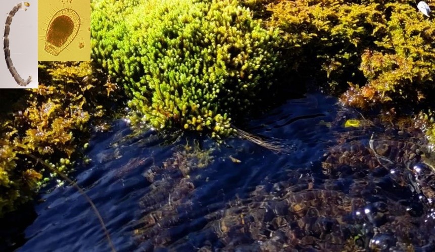
Climate change will have dramatic effects on water regimes above and below the ground. Specialist organisms occur in groundwater and colonize spring systems which may harbour a mixture of regular and accidental subterranean species as well as above-ground dispersers (e.g. insects). Thus, spring communities can be seen as model metacommunities with limited dispersal between them. In addition, many springs have very specific abiotic conditions that may drive their community composition. For these reasons, communities in springs may be used as “biotic tracers” of hydrogeological patterns. We will investigate spring habitats to address the following research questions: 1) What are the determinants of community composition of springs? 2) Can organisms be used as natural tracers and help to determine catchment areas of springs? 3) How will communities change with rapid changes in water regimes in the future? In two model sites in the Alps, we will generate hydrogeological maps and conceptual flow models, measure physico-chemical field parameters, hydrochemical and isotope composition and discharge variations. Tracer tests will be carried out in karst areas, where appropriate and possible. The springs will be sampled for organisms including crustacean and aquatic insect species. Samples will be analysed for living organisms as well as eggs and resting stages to allow an assessment of potential dispersal of organisms through the aquifers.
This project is part of the FWF-funded doctoral program on Alpine Geo- and Biodiversity during Environmental Changes (AlpsChange), which is integrated into the Doctoral School “Dynamic Mountain Environments and Society”
The Alps harbour high geo- and biodiversity and are highly impacted by past, present and future environmental changes. In our new doctoral program AlpsChange we join forces to develop a state-of-the-art interdisciplinary research and training agenda. With a consortium involving scientists across a wide range of disciplines including geology, geomorphology, ecological and evolutionary botany and zoology, as well as history, we ask: (1) What are the effects of environmental perturbations on geo- and biosystems, and how do changes in one system translate to the other system? (2) What are the feedback loops between geo- and biosystems? (3) Which past and future dynamics can be inferred when integrating data from geoscience, bioscience and history?
Our training program includes novel interdisciplinary educational offers and will facilitate the training of open-minded scientists fully aware of interactions between geo- and biosystems across a wide range of temporal and spatial scales. The new generation of experts will thus be able to bridge disciplinary gaps between the geo- and biosciences and to establish links to social sciences – skills that are essential to address the challenges caused by the ongoing climate and biodiversity crises. -
Landscape response to a changing climate in the Eastern Alps: Analysing Big Data for past, present and future conditions
Supervisor Team: Jörg Robl, Wolfgang Trutschnig, Wolfgang Meier, Andreas Tribsch, Bernhard Salcher
PhD Student: Henri Wilks-Stebbings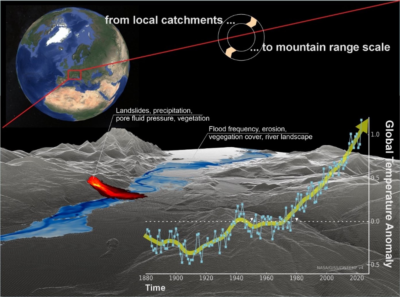
Field observations from alpine catchments suggest that climate change has triggered a morphological (hillslope and river dynamics) and biotic (vegetation cover) response. Changes in the coupled bio-geo-system are also detectable at the mountain range scale by remote sensing data that have been recorded for decades by various sensors with increasing spatial, spectral and temporal resolution. These data provide climatic variables as well as geological and biotic factors that make system changes observed at study sites also detectable at the mountain range scale. This project is about identifying and predicting landscape sensitivity in the Alps to climate change by computing past, present, and future changes based on field observations, remote sensing time series and climate model projections.Starting from local keys sites representing the drainage- and hillslope system, we will employ Google Earth Engine (GEE) and its wealth of freely available data characterising both biotic and abiotic factors. (1) Due to upscaling from catchment- to mountain range scale we will compute spatio-temporal gradients of biotic and abiotic factors across the Alps via GEE and the novel HPC facility at Salzburg University. (2) We will determine changes in the erosional potential of Alpine torrents based on climate variables recorded over the past decades and for future conditions as predicted by climate models. (3) We will work with supervised deep learning to detect hillslopes close to a critical state of failure considering both physical and biotic factors. (4) By synthesizing our results, we aim deriving the sensitivity of the landscape to climate change.
This project is part of the FWF-funded doctoral program on Alpine Geo- and Biodiversity during Environmental Changes (AlpsChange), which is integrated into the Doctoral School “Dynamic Mountain Environments and Society”
The Alps harbour high geo- and biodiversity and are highly impacted by past, present and future environmental changes. In our new doctoral program AlpsChange we join forces to develop a state-of-the-art interdisciplinary research and training agenda. With a consortium involving scientists across a wide range of disciplines including geology, geomorphology, ecological and evolutionary botany and zoology, as well as history, we ask: (1) What are the effects of environmental perturbations on geo- and biosystems, and how do changes in one system translate to the other system? (2) What are the feedback loops between geo- and biosystems? (3) Which past and future dynamics can be inferred when integrating data from geoscience, bioscience and history?
Our training program includes novel interdisciplinary educational offers and will facilitate the training of open-minded scientists fully aware of interactions between geo- and biosystems across a wide range of temporal and spatial scales. The new generation of experts will thus be able to bridge disciplinary gaps between the geo- and biosciences and to establish links to social sciences – skills that are essential to address the challenges caused by the ongoing climate and biodiversity crises. -
LUNAR
Projektleitung: Sumiko Tsukamoto, Dave Tanner, Christian Brandes, Christoph von Hagke
Dissertantin: Valentina Argante
This project is a collaboration with LIAG, Hannover. It is part of the DFG funded Priority Program “ Mountain Building Processes in 4-D”.
Der letzte Puls – Datierung der jüngsten Deformation in den Alpen mit ESR-Thermochronometrie. Mehr
-
Movement.at
Projektleitung: Christian Bauer, Gert Furtmüller, Oliver Gulas, Nadine Greenhalgh, Gerald Hartmann, Horst Ibetsberger, Andreas Kellerer-Pirklbauer, Martin Mergli, Jana Petermann, Hanna Pfeffer, Walter Poltnig, Jörg Robl, Andreas Schröder, Christian Uhlir, Benjamin van Wyk de Vries
Dieses Projekt wird von der Österreichischen Akademie der Wissenschaften. Beteiligt sind die Universität Graz, die Universität Salzburg, die drei österreichischen UNESCO-Global-Geoparks und verschiedene internationale Partner.
Erdrutsche werden als Geosystemdienstleistungen untersucht, wobei ein besonderer Schwerpunkt auf der Umweltbildung in den drei österreichischen UNESCO-Geoparks liegt. Mehr -
Old Mountains – Young Topography
Projektleitung: Christoph von Hagke, Jörg Robl, Bjarne Friedrichs
Dissertant: Fabian Dremel
Anwendung einer Kombination aus geomorphologischen Analysen, Niedrigtemperatur-Thermochronologie und numerischen Landschaftsentwicklungsmodellen zur Untersuchung der Reliefverjüngung. Mehr -
Thermo Calabria
Projektleitung: Christoph von Hagke, Bjarne Friedrichs
Dissertant: Nicolas Villamizar-Escalante
Anwendung der Thermochronologie zur Bestimmung der langfristigen Exhumierungsgeschichte der kalabrisch-ionischen Subduktionszone. Mehr -
TERRA
Projektleitung: Christoph von Hagke
Thermochronology and ERosion from River-dominated AlpineArchives
Geodynamic/Mountain Building processes derived from alluvial terrace (stratigraphy) and low temperature thermochronology
The north Alpine foreland basin and its fold-thrust belt are key sites for understanding the Miocene to sub-recent uplift and exhumation history of the Alps. In this project we will combine low-temperature thermochronological data from the Flysch and Molasse units in the Eastern Alps with stratigraphic evidence and fluvial terrace morphometry. Themrochronological measurements will focus on several deep drillings close to the leading edge of deformation of the Alps. This will allow for inferring the regional uplift signal. This data will be integrated with existing data from other parts of the basin. Terrace morphometry will be applied on an orogen-scale and on selected sub-regions such as the Drau-Region or Friaul. -
TRACE
Projektleitung: Christoph von Hagke
Tectonics, Relief and Climate in Exhumation
Exhumation in a fault-dominated mountain range: Tectonic unroofing versus erosional denudation
The transition from the Eastern Alps to the Southern Alps, with the Soboth, Pohorje and Karawanken Massifs separated from each other by crustal scale strike-slip faults, provides an excellent setting for investigating the different influence of these two major processes. To characterize the various contributions of tectonics and climate to exhumation, we will combine the results of a digital terrain analysis with thermochronometry and catchment-wide erosion rates across these fault-dominated mountain massifs. -
TRIANGLE
Projektleitung: Christoph von Hagke
Anwendung einer Kombination aus analogen und numerischen Modellen in Verbindung mit Feldarbeit, um mehr über die Mechanik von Dreieckszonen in Verformungszonen zu erfahren. Mehr -
Shelter under Shards
Supervisor Team: Christoph von Hagke, Anja Hörger, Jan Habel, Jonas Eberle
Habitat changes quantify growth of dilatant rock fracture networks in mountain belts
Under a rapidly changing climate, mountains react with increased erosion rates and consequently formation of open rock fractures. While on the one hand, such fractures may result in geohazards such as rock falls, they may on the other hand form local habitats and micro-climatic niches. While their geometry has been studied in detail, their time evolution is challenging to constrain. Particularly, it is unknown how rapidly these fracture networks evolve under changing climate. This knowledge is however vital for determining how such fractures develop into geohazards or into micro-habitats. on Indeed, micro-habitat evolution may be used to determine fracture growth rates. In turn, it is important to assess how ecosystems can adjust to different rates of fracture propagation and consequently evolving micro-habitats. We hypothesize that fracture growth in dynamically changing mountains forms local habitats in which different species can find niches sheltering them from large-scale landscape changes. They form local bio-diversity hotspots. In turn, the degree of soil formation, the diversity of inhabiting species as well as the type of species present provide information on the time evolution of fracture growth.


