
Geoinformation – Digital Earth
| TYPE | SUPPLEMENTARY STUDY PROGRAMME |
| REQUIREMENTS | 24 ECTS |
| COORDINATION | Department of Geoinformatics – Z_GIS |
| CONTACT | Dr. Manfred Mittlböck |
| COURSES | Winter 2025 / Summer 2026 (PLUSonline) |
| DETAILS | University gazette, 1 August 2024, No.148 The supplementary study programme “Geoinformation – Digital Earth” replaces “Geographical Information Systems – GIS.” Certificates according to the regulation of the Vice-Rectorate for Education and Student Experience on the supplementary study programme and specialisation programme “Geographical Information Systems” at the University of Salzburg. Bulletin from January 25, 2017, Number 52, can still be issued until September 30, 2025. |
Focus
The supplementary study programmes offer all university students a fundamental interdisciplinary qualification in geoinformation, elementary geoinformatics methods, and based on the concepts of Geographic Information Sciences. This supports the transversally oriented spatial segment of an information and knowledge society. It also promotes the process of digital transformation and provides science-based decision support.
Goals & Focus Areas
The goals of the supplementary study programmes include orientation in the spectrum of geoinformatics tools, as well as acquiring conceptual foundational knowledge, technical skills, and methodological competencies for problem- and solution-oriented application of Geographic Information Systems.
The supplementary study programmes identify “Digital Earth” as a transversal perspective, orienting itself at the intersection of humans with digital models and representations of reality. These interactions enable learning, understanding, and decision-making, especially for central and critical issues in society, politics, and the economy.
Graduates of the supplementary study programme will be able to:
- Select and configure geodata appropriately for projects.
- Capture and organize georeferenced data from sensors and documents.
- Generate information from the analysis of spatio-temporal data.
- Visually design and communicate data and information using geomedia (web maps, story maps, dashboards).
Structure & Requirements
Basic Module (12 ECTS)
For the Basic Module, courses totaling 12 ECTS points from the following areas must be completed. Courses from your own field of study may only be chosen if they are not part of the mandatory or elective subjects. An exception to this rule is courses from the cross-sectional module on socio-ecological crises, which cannot be credited as free electives.
- Fundamentals of Geoinformation and Digital Earth (6 ECTS)
- Additional elective courses from the following topics (6 ECTS, with a maximum of 3 ECTS from online courses MOOC/EsriAcad):
- Data Capture and Data Integration
- Digital Decision Support and Data Protection
- Geomedia, Spatial Interaction, and Geovisualization
Advanced Module (12 ECTS)
For the Advanced Module, courses totaling 12 ECTS points from the following areas must be completed. Courses from your own field of study may only be chosen if they are not part of the mandatory or elective subjects. An exception to this rule is courses from the cross-sectional module on socio-ecological crises, which cannot be credited as free electives.
When selecting courses for the Advanced Module, it should be noted that for the supplementary study programme, courses must be completed from at least two of the three specified elective topic areas:
- Fundamentals of Geoinformation and Digital Earth (6 ECTS)
- Additional elective courses from the following topics (6 ECTS, with a maximum of 3 ECTS from online courses MOOC/EsriAcad):
- Data Capture and Data Integration
- Digital Decision Support and Data Protection
- Geomedia, Spatial Interaction, and Geovisualization
Certificate
After successfully completing the courses listed above, the following certificates can be requested:
- Basic Module “Geoinformation – Digital Earth: Orientation”: This will be issued after successful completion of the Basic Module totaling 12 ECTS points.
- Supplementary Study Programme “Geoinformation – Digital Earth: Perspectives”: This will be issued after successful completion of both the Basic and Advanced Modules, totaling 24 ECTS points.
Course Registration & Requesting a Certificate
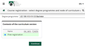
Registration for individual courses is done via PLUSonline.
Note: For courses taken as part of the supplementary study programmes, select “Free Registration” in PLUSonline during course registration:
Once you have completed the required courses, submit the completed exam pass and the corresponding certificates to Dr. Manfred Mittlböck. After verifying the documents, the certificate will be issued by the ZFL – Flexible Learning on behalf of the Vice-Rectorate for Education and Student Experience. If it is not possible to print the transcripts from PLUSonline, only submit the completed exam pass.
IMPORTANT: It is possible to include supplementary study programmes and specialisation programmes in the Bachelor’s, Master’s, or Diploma examination certificate (naming of free electives). Regulations can be found in your curriculum, or you may need to reach an agreement with the chair of your curriculum committee beforehand.
Download Exam Pass
- Exam Pass Basic Module Geoinformation – Digital Earth: Orientation (12 ECTS)
- Exam Pass Supplementary Study Geoinformation – Digital Earth (24 ECTS)
Contact
Dr. Manfred Mittlböck
Department of Geoinformatics – Z_GIS
Schillerstraße 30/III, 5020 Salzburg
Tel.: +43 662 8044 – 7531
E-Mail:


