
MSc Copernicus Master in Digital Earth
The Copernicus Master in Digital Earth is an international multi-partner Erasmus Mundus Joint Master. In addition to studying in the first year at University of Salzburg and in the second year at the chosen specialization partner (University of South Brittany or Palacký University Olomouc), students are exposed to further experiences aimed at integrating the student body across partners as well as providing opportunities to connect with global regional specificities through involvement in associated partners, in the form of internships, research mobility and participation in short intensive programs. The Master of Science program is offered as double degree in English language.
Study Earth Observation and Geoinformatics in the first academic year. Two Specialization Tracks offer outstanding candidates a pathway towards excellence in GeoData Science as well as GeoVisualization and Geocommunication in the second year of studies. The program is scientifically based, offers a broad spectrum of scientific analysis and research methods, and prepares students for doctoral studies. It imparts application-oriented knowledge based on relevant theories and methods. Discipline-specific thinking, analytical skills and techniques, and problem-solving skills are developed in core areas of Copernicus and Digital Earth, specifically in:
- Geospatial data acquisition and visual / cartographic communication;
- Data modeling and geospatial data management;
- Data analytics across the geoinformatics spectrum: georeferenced data and data streams; in-situ, remote, and mobile sensing; statistics;
- Spatial analysis, and dynamic system simulation;
- Standards for architectures of open and distributed systems and spatial data infrastructures;
- Geospatial application development.
Study path
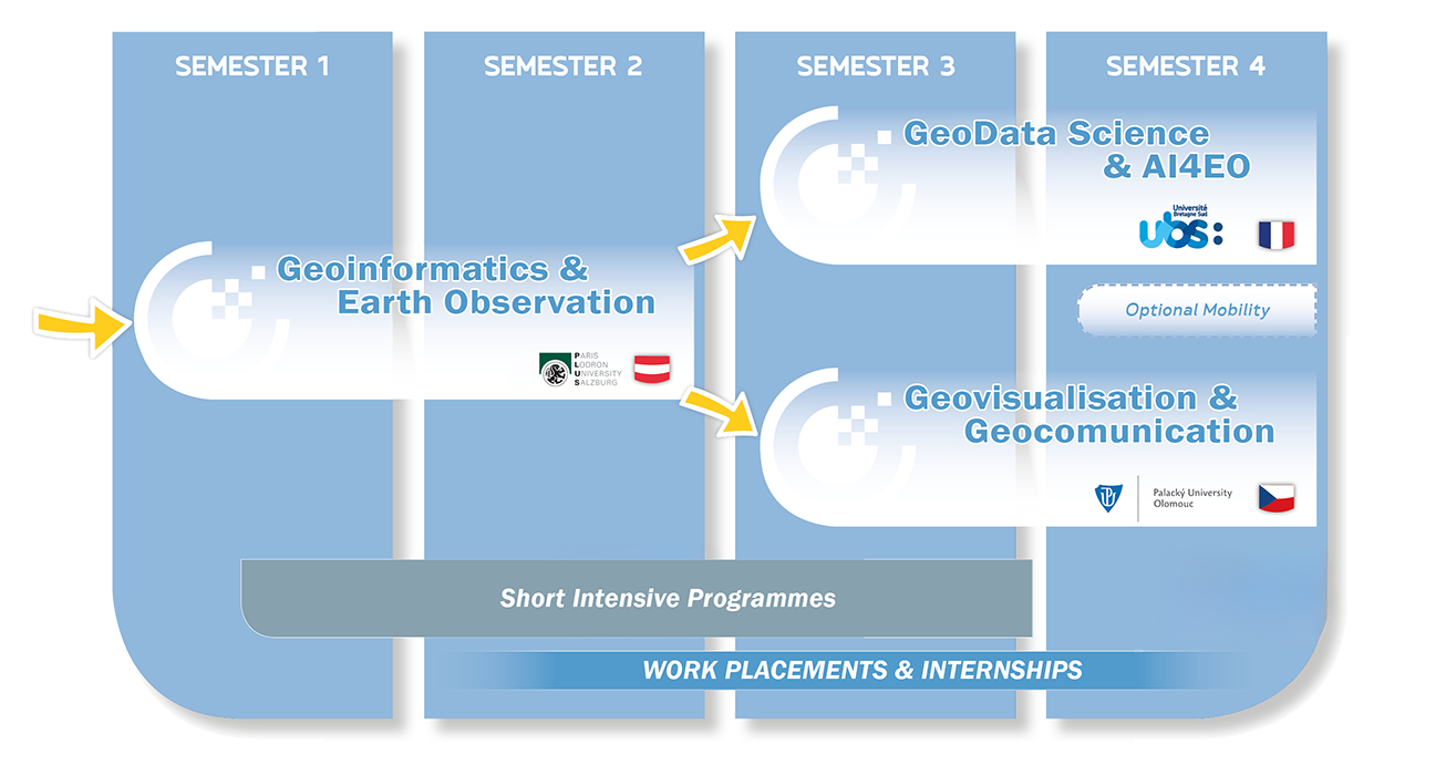
Specialization Tracks
The overall program structure reflects the cooperation of the Higher Education partners, and is directed at supporting the key qualification objectives for a study program which simultaneously will aim at broad-based advanced Geoinformatics, Remote Sensing, Cartography/Geovisualization, Computer Science as well as a applied emphasis on use cases with Copernicus data and services within the main Copernicus domains under a generic Digital Earth vision. One starting place for all students aims to establish a strong common denominator in Earth Observation and Geoinformatics for the first two semesters, before continuing towards a specialization track in either Geodata Science or Geovisualization and Geocommunication. For admission there is a qualification based selection process, we offer two annual calls for applications.

Erasmus Mundus Joint Master (EMJM), co-funded by the European Union, CDE – Copernicus Master in Digital Earth


